Northwest Territories Thermokarst Mapping Collective
Description
Permafrost thaw is a primary cause of climate-driven landscape change in the north and has a major effect on ecosystems and infrastructure. Understanding the distribution of thaw-sensitive terrain is critical to predicting the future state of the environment and water resources of the Northwest Territories’ (NWT), and for planning community and infrastructure adaptation to climate change. The objective of the NWT Thermokarst Mapping Collective is to establish a collaborative approach to develop and implement a mapping methodology to generate NWT-wide thermokarst and permafrost feature inventory maps. Preliminary mapping will be focused on areas around NWT communities. Outputs will provide information relevant to all NWT regions, inform and validate modeling efforts, and support community climate change adaptation.
Location
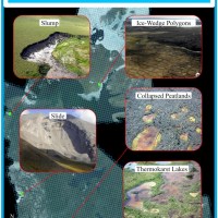
To map sensitive permafrost terrain across the NWT we involved experts from across Canada to develop a methodology for identifying thermokarst landforms. The mapping methods were grouped into the following themes: A) Thawing slopes and mass-wasting; B) Hydrological features; and C) Periglacial landforms. The project team tested the methodology using Sentinel imagery and assessed the presence and abundance of permafrost features, then classified 7.5x7.5 km grid cells within a 75x75 km gridded area for each of the 33 NWT communities. The second component of this project involves training northern students and project partners to use this method to create inventory maps for the entire NWT and the adjacent Provincial/Territorial transboundary watershed areas.
Justification
There are several local-scale mapping products that describe the nature, intensity and distribution of thermokarst processes and permafrost landforms, but there are no observationally based maps describing the distribution of landforms indicative of permafrost thaw or sensitive terrain that cover the entire NWT. This project is based on interpretation of map based products, relies on collaboration amongst experts and involves northerners in the generation and analyses of the mapping products.
Approach
A collaborative team of government and academic researchers have developed an empirically-based mapping methodology to locate thaw-sensitive permafrost terrain by identifying key mass-wasting, hydrological, and periglacial features indicative of thermokarst. Through an iterative process, mappers use Sentinel-2 10 m satellite imagery with a 7.5 x 7.5 km gridded cell system to inventory the location of these thermokarst features throughout the NWT using GIS software. A strong QA/QC processes is then applied to validate the empirically-based mapping effort.
Schedule
This project began in 2019 and is building on the broad-scale classification framework described in Kokelj et. al (2017) to map the distribution of thaw slump-affected terrain across northwestern Canada. Methodologies have been developed, and mapping the territory and communities are well underway. Results from the community mapping effort are expected in early 2022, while the territory-wide transboundary product is expected to be ready summer of 2022. Plans for this project include the publication of GNWT open-reports and maps including user-friendly interactive platforms, as well as peer-reviewed journal articles.
Partners and Support
Wilfrid Laurier University
Aurora Research Institute
NWT Centre for Geomatics
Department of Environment and Natural Resources
Prince of Wales Northern Heritage Centre
Geological Survey of Canada
Yukon Geological Survey
Queen’s University
University of Guelph
University of Victoria
University of Ottawa
University of Auckland
Ehdiitat Renewable Resources Council
Tetl'it Renewable Resources Council
Inuvialuit Land Administration


