Research and Activities

The Northwest Territories Mining Incentive Program (MIP) provides funding to prospectors and exploration companies who propose new exploration...
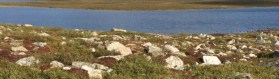
The Slave Province is a geological formation that lies between Great Slave Lake and Coronation Gulf. The area contains some of the oldest known...

An annual review of mineral exploration and resource development in the Northwest Territories.

The geology of the Selwyn Mountains in the western Northwest Territories is poorly understood, even though it is rich in critical mineral resources...

The aeromagnetic data can illustrate the presence of certain rock types, anomalous zones and structures in the Earth’s upper crust. To achieve this...
")
Airborne electromagnetic and horizontal-gradient magnetic survey of the central Slave craton area, Northwest Territories

A previously poorly understood area of the northern Mackenzie Mountains was mapped to improve understanding of its geological history and potential...

To aid exploration and industry requirements, the Northwest Territories Geological Survey has an upcoming high-resolution aeromagnetic survey in an...

Permafrost terrain is changing across the Northwest Territories, often resulting in major environmental and societal impacts. Information about...

Amblygonite and montebrasite are lithium phosphate minerals which form end members of a solid-solution series and occur in granitic pegmatites...
 pegmatite dyke under a thin metasedimentary surficial layer.")
The Slave Geological Province is known to contain numerous occurrences lithium-cesium-tantalum (LCT) and niobium-yttrium-fluorine (NYF) pegmatites,...

The geology of the Flat River - Howards Pass area in the Selwyn Mountains (western NWT) is poorly understood, even though it's rich in minerals...

This publication describes the geophysical interpretation of an aeromagnetic survey conducted in the central Slave craton area (CSC), Northwest...

This project investigates potential reservoir formations for carbon storage in the Mackenzie Delta and Colville Hills of the Northwest Territories....

Geothermal energy is thermal energy generated and stored in the earth. It is generated by the radioactive decay of Uranium, Thorium, and Potassium in...

The purpose of the mapping project is to show the well locations and quantity of the conventional gas resources in the mainland NWT outside of the...
")
The Northwest Territories Geological Survey Geological Materials Storage Warehouse and viewing facility allows clients to access and study our core...

Permafrost is a geological manifestation of cold climate, which affects terrestrial and aquatic ecosystems and influences virtually all community and...