Shale Basin Evolution in the Central NWT
Description
There is potential for the discovery of new shale oil and gas reserves in NWT’s mainland basins because of the known high quality, mature source rocks identified, primarily in the Devonian age Canol and Hare Indian formations and the Cretaceous age Slater River Formation. Existing framework geoscience and datasets established during the Mackenzie Plain Petroleum Project require crucial detailed study to characterize shale reservoir units. New information from the adjacent Peel Plain and Plateau is needed to expand the knowledge of hydrocarbon resource potential and map organic-rich fairways. A detailed chronostratigraphic interpretation of the Givetian to Middle Frasnian period of shale basin evolution in the studied regions will be undertaken.
Justification
The goal is to map thermal maturity trends and differentiate oil-prone and gas-prone potential shale reservoir units in both Devonian and Cretaceous rocks. Legacy core and rock samples will be analysed through various techniques to improve knowledge of petroleum systems in the region. Use of this improved geoscience information supports current and future exploration activity, as well as underpins land use and resource management policies and decisions.
Approach
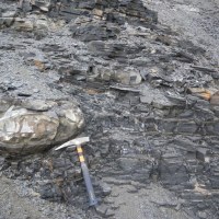
Field and core investigations involve detailed examination of sedimentary features and spectral gamma ray measurement throughout the thickness of the stratigraphic intervals at each outcrop and core. Rock samples will be collected to evaluate: 1) source and reservoir rock potential (total organic carbon, porosity, permeability), 2) thermal maturity, 3) thermal history, 4) mineralogy, 5) whole rock geochemistry 6) carbon isotopic signatures, 7) fossils, 8) oil stain and seep inventory, 9) sedimentary grain provenance, 10) ichnology, and 11) absolute ages using carbon and oxygen isotope, rhenium and osmium and conodont dating. Sampling will be conducted on select outcrops and core at a sampling frequency to facilitate the determination of chronostratigraphic surfaces for regional correlation. Additional work will include the interpretation of the available regional seismic data and the incorporation of all pertinent data sets into basin modelling studies.
Schedule
The field and subsurface project was initiated in 2014. Helicopter-assisted field seasons were completed in 2014, 2016 and 2018. The 2014 season focused on the Central Mackenzie Plain, whereas the 2016 and 2018 seasons focused on the southern Peel Plateau and the western margin of the Mackenzie Plain. Results of the project to date are currently published (2014) and in preparation (2016, 2018) as Open Files. Seismic data covering the Mackenzie Plain and portions of the Peel Plain was purchased during Fiscal 2017-18. These data will be interpreted in the spring of 2019 and will result in an integrated regional mapping interpretation for these regions. This project is ongoing and will not be completed until approximately 2021.
Keywords
RE/TOC, chemostratigraphy, Devonian shales, Cretaceous shales, shale gas or oil play, vitrinite reflectance, rock- eval, total organic carbon, Peel Plateau, Peel Plain, Mackenzie Plain, Canol, Bluefish, Slater River, Arctic Red, chronostratigraphy, seismic interpretation, basin modelling studies.


